I had the pleasure of cycling across the full width of Kentucky in 2019. I was in a bit of a time crunch, however, and knew that cycling more of Kentucky’s Bourbon Country was a bucket list item.
When the opportunity arose to revisit the area, I was similarly under a time crunch–but then again, I usually am. In this case, my wife had a work trip to Cincinnati, which was just across the river from Kentucky. If I took that Friday off from training clients at the gym, I’d be able to cycle as far as I wanted to on that Saturday while my wife was attending her work conference. The weather looked favorable–lows around 50 and highs around 80.
I saw my chance at another go around Kentucky and I took it.
Arriving
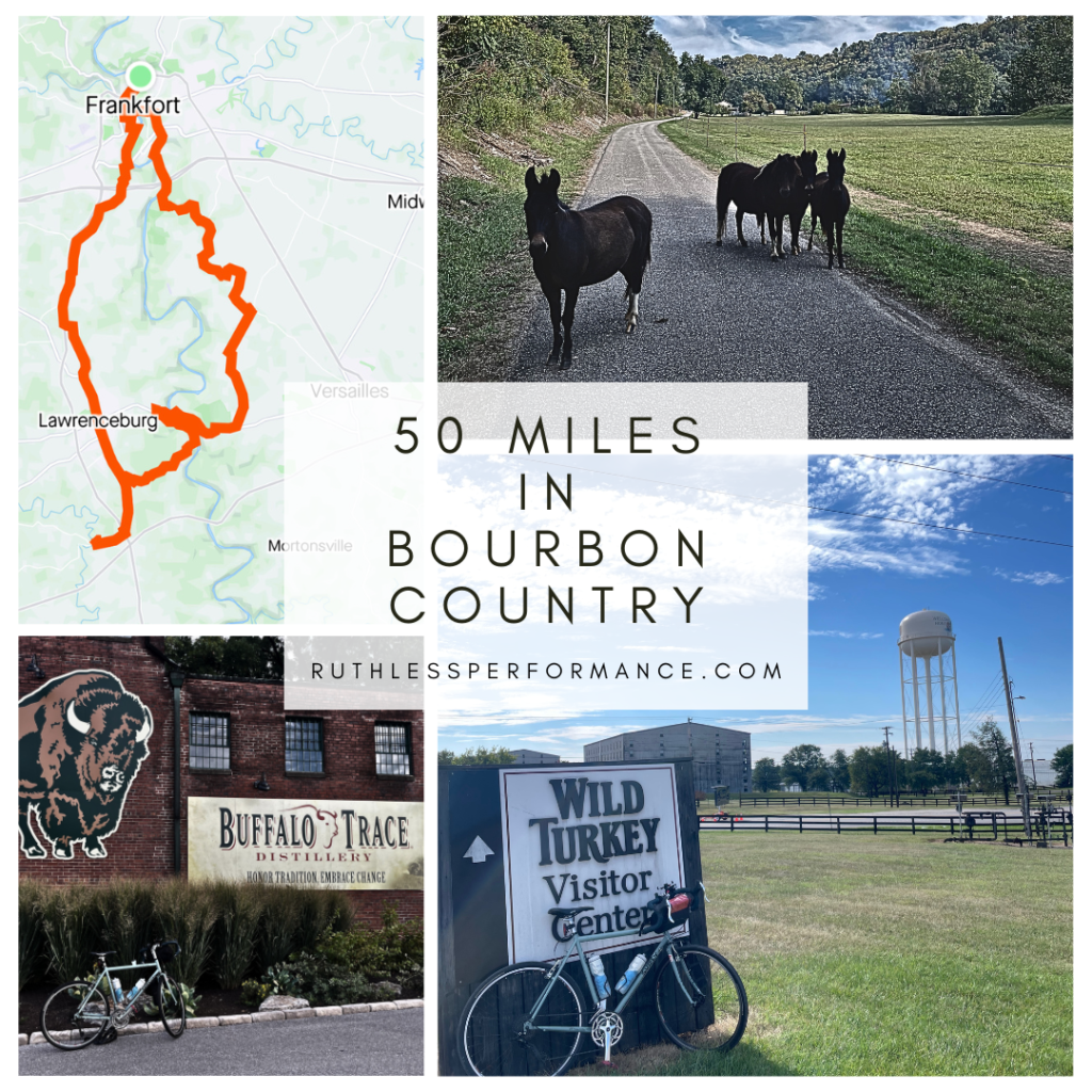
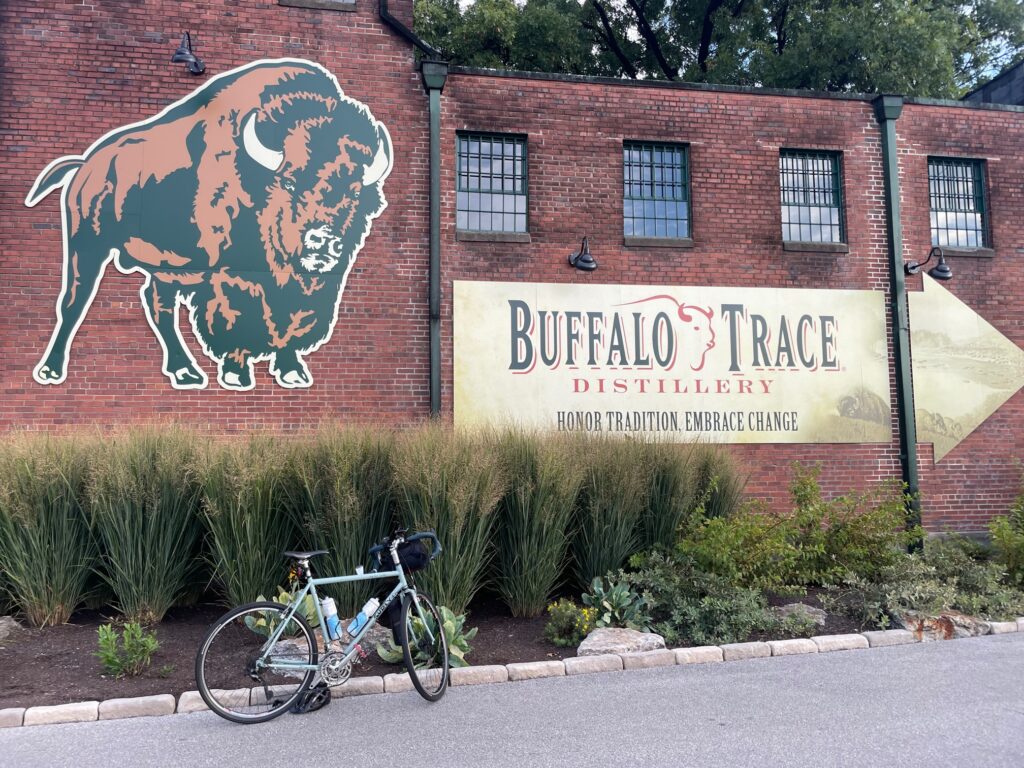
From Cincinnati I was an hour and a half drive away from Buffalo Trace Distillery in Frankfort Kentucky. I left the hotel in Cincinnati around 6:15 and was parked and ready to cycle starting at the Buffalo Trace visitor lot before 8:30 AM. Since Buffalo Trace opened at 9:00, I thought that I would be alone at my starting point, but evidently the early bird gets the rare warehouse releases. Later on, I was told that a line starts forming at Buffalo Trace (“BT”) around 7:00 for the day’s limited releases–and a line there was. Since I wasn’t about to spend the first few hours of my day standing in line, I paid little attention to this. I’d estimate the line was around 120-160 people by the time I started my ride. This was on a Saturday morning, so that may have contributed to the longer line.
This will be my first tip to any cyclists hitting the trail: don’t plan on stocking up on too many bottles on your riding day.
1st Leg: Buffalo Trace to Four Roses (20.7 Miles)
I knew later that day, I’d have to pick my wife up from her conference, so I wanted to cover the greatest distance first thing in the morning. This way, I’d have a safety net for time as the day progressed. Then the plan was to slowly work my way back to my starting line at Buffalo Trace.
An issue I had when e-scouting this route was the city of Frankfort. I knew that most of the routes I could take would send me through downtown. Not having a great idea of what Frankfort was like, I was somewhat concerned.
If you’re planning to ride the bourbon trail and need to make your way through Frankfort, not only is it easy to navigate, but there are almost always wide shoulders and a variety of coffee shops, restaurants, and anything else you may need to start or end a ride on a strong note.
These concerns ended up being unfounded. Frankfort was a lovely, small city, very easy to navigate on the bike. And since I was driving through town at 9:00 AM on a Saturday, the traffic was minimal.
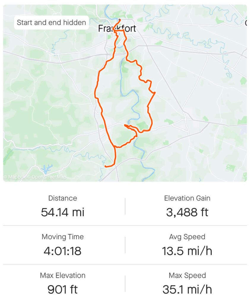
I’ll include a map of my route so that you can get a better understanding of my path but this route was meant to create a loop rather than an out-and-back, giving me an even wider array of scenic Kentucky to explore.
In short, my route on this leg took me along Old Lawrenceburg Road, Lawrenceburg Road, Main Street in Lawrenceburg (another town with some shops and restaurants), Harrodsburg Road, then Bonds Mill Road right to the first destination of Four Roses.
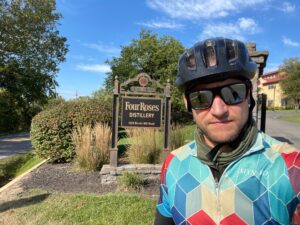
I’m not much of a drinker these days (I used to be a lot of fun, though). But Four Roses Visitor Center has a short but well-designed drink list, lots of merchandise in the shop, plus water. I was able to refill some of my bottles here to keep hydrated—an important step, particularly if you’re going to be grabbing cocktails along the route.
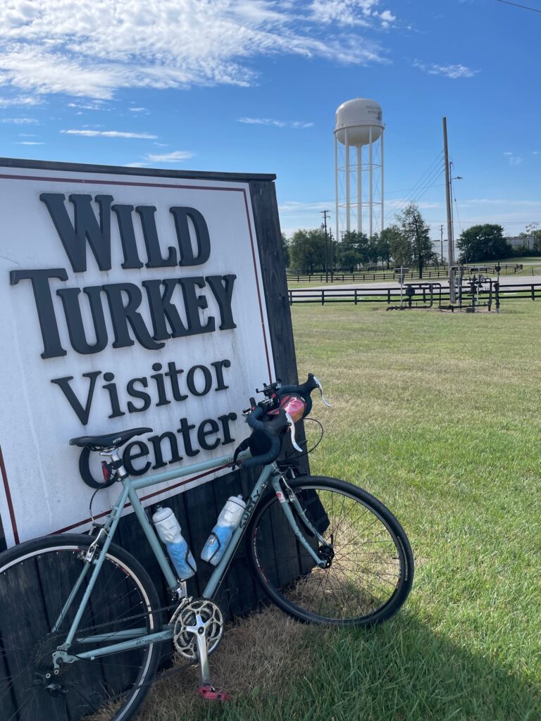
2nd Leg: Four Roses to Wild Turkey (8.5 Miles)
I don’t think there are too many wrong answers when it comes to routes between these distilleries, but this is a segment that I enjoyed and that I do recommend—provided that you are riding with gravel tires.
First, you’ll have to shoot back up Bonds Mill Road, Harrodsburg Road, but then Wildcat Road (1510). This was my favorite part of the whole ride. It gets a little sketchy, I couldn’t imagine what its like after rain, and it does get down to a dirt road. You’ll be rewarded with significantly less traffic and a very scenic environment. There are very few turns once you’re on Wildcat Road, basically until you see the Wild Turkey temporary gift shop on your left.
Again, gravel tires only (unless you’re really comfortable with taking your bike on the dirt) and you’ll need to manage a (paved) hill climb up from the Kentucky River up to Wild Turkey. I’m pretty advanced when it comes to hill climbs, personally I thought it wasn’t too bad, and again, there is very little traffic to worry about.
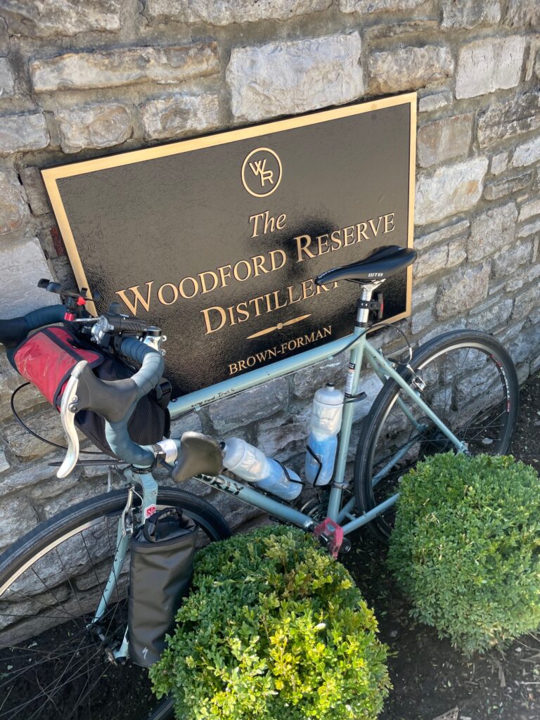
3rd Leg: Wild Turkey to Woodford Reserve (11.2 Miles)
This leg of the trip starts almost immediately with a picturesque bridge crossing over the Kentucky River. The Tyrone Bridge was very scenic. Partially due to vehicular traffic, partially due to me wanting to get across this span I didn’t stop for any pictures. It is, however, as scenic as Kentucky gets. I had no issues with crossing on the bike. Immediately after the bridge, there is a hill climb, where cars may start to accumulate behind you, but I was never rushed, and vehicles tend to find their way around when a safe opportunity arises.
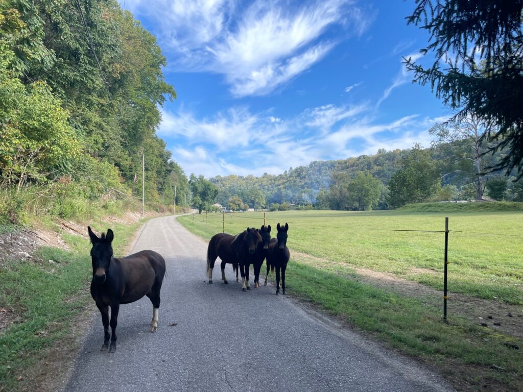
From the Tyrone Pike, I took Milner Road then Steele Road. Steele Road is a two-way road but is probably about 1.5 lanes wide. I didn’t see any vehicles for much of this segment and was again happily greeted by some very scenic KY countryside.
Against my better judgement, for most of this ride, I was listening to music. When paired with my already prominent hearing loss, this could undoubtedly become a very dangerous situation. But, for safety’s sake, I would turn the music off in congested areas and towns. I also utilized a portable Bluetooth speaker that I had attached to my handlebars rather than earbuds.
I listened to the Kentucky Bluegrass playlist on Spotify by Alexander Davey. I think this is just some bro’s playlist which happens to be publicly listed but this playlist did a damn good job of matching the environment.
Rather than heading to the visitor’s center at Woodford Reserve, I spent some time in their cocktail lounge. This was the first time on the trip where I began to realize how the bourbon trail closely resembles some of the more well-known wine trails in the US (I’m thinking of California’s Central Coast in particular). The other visitors here were markedly friendly, making for an even more relaxing break.
Woodford Reserve to Castle & Key (3.4 Miles)
Once you’re at Woodford Reserve, and alongside Glenn’s Creek you’ll be near a handful of distilleries on your way north back to Frankfort.
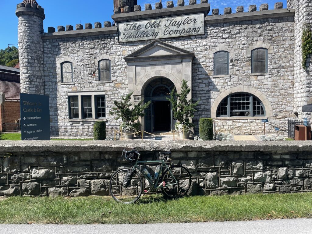
Castle & Key is notable for its behind housed in an actual castle. This is only a short 3.4 mile cycle from Woodford Reserve and makes for another very cool stop. This wasn’t as crowded as some of the other distilleries so far along the route, which I’ll attribute to its more limited distribution.
Along this section, there is a restaurant. I was so caffeinated this morning that I actually had very little to eat along the route. Some cookies, some pretzels, lots of electrolytes. The Stave is a restaurant and bar right in this section which does look like it has some good food and a solid drink selection.
Right around this point I started seeing some signs for road closures ahead, detours, and all those kinds of fun things that you love to see when cycling. My policy, probably against sound legal advice, has always been to ignore these types of signs until they become a real issue that I am confronted with.
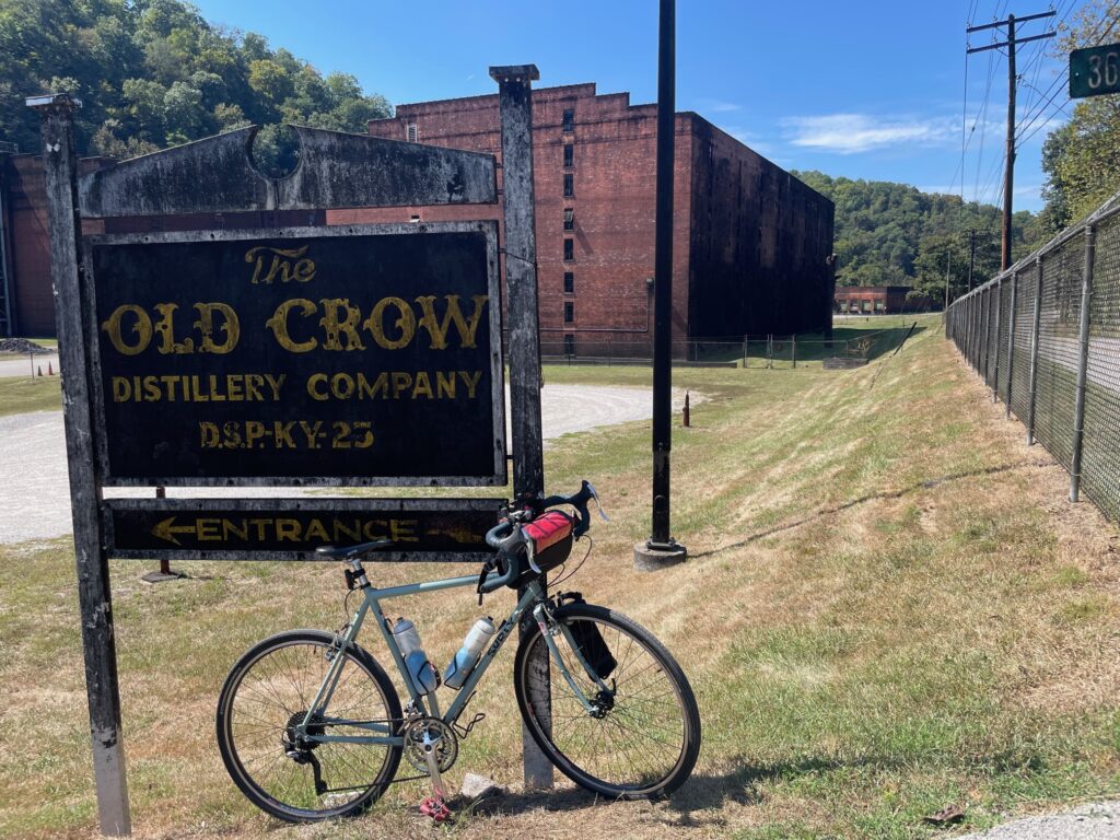
Castle & Key to Old Crow (0.6 Miles)
The length of McCracken Pike is very concentrated bourbon country. From Castle & Key to Old Crow was just a 0.6 mile jaunt down the road.
The Old Crow Distillery was very much in line with my experience of the stuff in college. I didn’t go in, I didn’t know if I could go in, and was happy to see this place from the road. This is still very much a working distillery, and they do (so they say) have tastings every hour from 10-4. Check it out and you be the judge.
I wasn’t in an Old Crow tasting mood, partially for fear of reawakening some intense collegiate hangover memories, but the option is there.
As I continued, I was seeing more signs for a road closure ahead which I continued to ignore (again, ignoring road signs that I don’t like isn’t a recommendation, it’s just a cycling policy of mine).
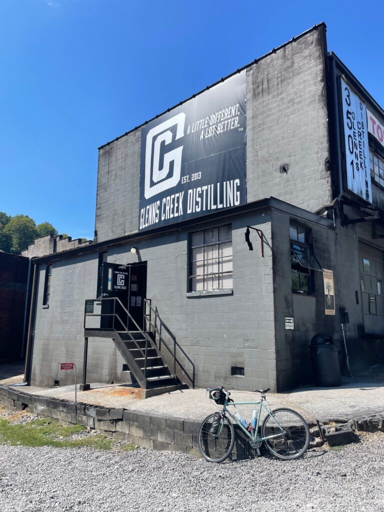
Old Crow to Glenn’s Creek Distillery (0.2 Miles)
By the time you clip into your pedals you’ll already be at Glenn’s Creek Distillery. Glenn’s Creek is another lesser-known distillery, but it is home to a few different brands. I’d recommend a stop here just to see what’s beyond the bigger distilleries with broader distribution.
Glenn’s Creek Distillery to Buffalo Trace (7.0 Miles)
Immediately after the gate from the road into the Glenn’s Creek Distillery parking lot was the road closure which I was fearing.
Now there weren’t just ‘road closed ahead’ signs but there were barricades across the road to prevent traffic from attempting to get by. Not one for backtracking, I continued to try my luck and rode right on past this first set of signs and barricades on the road closure.
Shortly after I came across another barricade, this one explicitly stating no bikes are allowed on this road either—I must not have been the first to try. This closure, however, was not listed on any of the GPS directions so depending on how shortly after publication that you read this, you may find yourself in a similar predicament.
I continued ahead to the road work site, which was definitely the reason for the closure, right alongside the Kentucky River. Had I been doing this ride during the week, I’m sure I would’ve come across some disgruntled construction workers (which has happened to me before).
Again, not recommending you ignore road closure signs, it just happened to work out for me. The good news is that this means that sooner than later this whole section of road will be resurfaced and make for some nice riverside riding.
My GPS yet again let me down on this leg, trying to take me down a foot-traffic only path on Kentucky State’s campus. To avoid this, I turned left on Hwy 60 towards downtown Frankfurt. This road does have some pretty serious traffic, but this segment is downhill so you can easily keep up or even outpace traffic on this descent.
From Hwy 60 I continued straight onto W Main Street in Kentucky. Here I continued my caffeine binge with a cold brew from Engine Coffee House. I sat at a table outside of the coffee shop and was able to gather my first couple of thoughts on the ride: the hills were very minimal, the traffic was great, AND I probably could’ve wedged in even a few more distilleries had I really put my mind to it.
Once I got back at it again, I continued to the end of Main Street onto the Riverview path. This riverwalk is bike accessible and will take you right back to the gates of Buffalo Trace.
Thoughts on the Ride
I don’t much consider myself a true cyclist and I was riding a heavy steel-frame Long Haul Trucker. So, for more experienced cyclists with more road friendly bikes and tires, you could probably crush this route very rapidly. I had no real goal for this ride other than to familiarize myself with the terrain so that hopefully I can come back with a few friends to knock out even a few more distilleries along the way.
If there are a few distilleries that you want to cycle to, you’ll almost certainly be able to find a bike-friendly route. I did my initial e-scouting with Google Maps which I thought did a fairly good job, except for the road closure and trying to take me on a walking path, but these were easily overcome by the accessibility of Kentucky’s road system for cyclists.
This was certainly a bucket list ride for me, although it was my second time here on a bike, and my fourth time overall. But I would not let fear of the unknown prevent you from taking a stab at this route or one like it.
When you come across a busy road, the shoulders are normally sufficiently wide enough to safely accommodate a bike. Traffic is very accepting of cyclists and there are more than enough food and beverage options to go ultralight and cover some serious mileage.
If you have an interest in adventure cycling or simply seeing bourbon country by bike it is very easily within your grasp. There are group cycling tours, which can provide you with expertise and back-up equipment. But do-it-yourselfers should not be scared—Bourbon Country is Cycling Country.
Have questions about cycling Kentucky’s Bourbon Trail? I’m no expert but I can try to help. And as always if you’re interested in training so that you’re ready to tackle a challenge like this when an opportunity presents itself, you can train with us in-person at our Pottsville, PA location or anywhere online.